

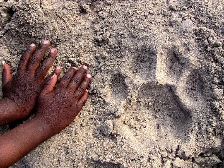
From spotting your first print to seeing it added to the database — here's the whole path a submission takes, one step at a time.
Footprints can be found anywhere there are animals and where the substrate is suitable. Sand, snow, mud, or dirt are great for detecting prints. When you are on the trail or on a safari, look down. You will be surprised by how many prints are just below your feet!
Use a metric ruler in your photo — this is important for determining the print size and proportions. Capture the print from above, positioning your camera directly overhead for the best contrast. Turn on your GPS location while using the app so we can accurately map your observation. Submit one single print of each foot along with an image of the entire trail, which lets us examine the stride and motion of the animal in addition to the footprint itself. Keep looking — there are often multiple trails from multiple animals in the same area, especially around water, so submit a new observation for each different animal.
You can use the WildTrackAI app (iOS or Android) or upload images directly on our AI platform.
Your observation images will be sent to the WildTrackAI cloud hosted by AWS where they'll be stored securely, reviewed by experts, and modeled by AI to contribute to the development of the database, helping to protect endangered species. You will be able to see the status of your submitted observations on your dashboard on the app and when you log into the database.
Log in to the platform to see leaderboard data, maps, and species lists.
We would love to hear from you.
Contact usWildTrack is a 501(c)(3) nonprofit that uses animal footprints to identify, monitor, and protect wildlife. We combine footprint analysis with AI and ecological expertise, so we can learn about animals without seeing or capturing them.
To protect at-risk species, we need to know where they live and how they're faring: how many there are and where they roam. That information is hard to gather at large scales with today's methods. Footprints are far easier to find than the animals themselves. By working with communities spread across wide areas, WildTrack gathers much more data, often from places conventional research doesn't reach. We turn those tracks into data that shows researchers where species live, how populations change, how animals move, and how their use of habitat shifts over time.
A footprint works like a fingerprint. Its shape and size can reveal the species and, for some species, the animal's sex, age class, or even which individual it is. Tracks also show where animals move and how populations change over time.
FIT is the method at the heart of WildTrack. It takes a simple image of an animal footprint and uses the geometry of a footprint and machine learning to identify the species and, for some species, the sex, age class, and individual.
Learn about FITFootprint tracking is non-invasive: no capturing, tagging, or handling animals. Tracks turn up where cameras aren't practical, and they hold physical details cameras can miss.
Footprints are everywhere, and can provide information that cameras don't always capture. They can be found in places where cameras aren't practical, and the physical characteristics of a track can contain information about the animal that made it.
No. It doesn't require capturing, tagging, or handling an animal. In the field, always follow responsible wildlife-viewing practices and avoid disturbing animals or sensitive habitats.
No, and we don't want it to. Expert humans in the field, whether trackers, researchers or people with both skills, drive our research. The technology just accelerates and assists. The true power of AI is with expert human collaboration and interpretation.
WildTrack was founded in 2011 by Drs Sky Alibhai and Zoë Jewell, and is based in Durham, North Carolina. Our multidisciplinary team of experts in field tracking, data science, machine learning, engineering, design, operations research, and other disciplines drives our unique research approach forward.
Meet the teamThe app lets you submit animal tracks and contribute observations to WildTrack so that we can build identification models for species and protect them. Right now we're working towards providing users with immediate feedback on the ID of the track. Our current models can already do this; we're making sure that our outputs retain security for endangered species before we make it public.
Yes, the app is free. It runs on iOS and Android.
Get the appDownload the WildTrack app, create an account and look for some tracks! When you find a track, follow the steps in the app to image and submit it.
No. The app is built for all experience levels. You don't need to be a professional tracker to contribute.
Anywhere in the world, from a national park or your favorite hiking trail, to your back yard or remote areas where people rarely go!
Our models can currently identify species from rhino and lion to tiny mice! We have more than 1,000 species in our database and we're adding more all the time, so please submit tracks of any wild species: unknown tracks help us build new models.
Yes! You can record observations offline, and they upload automatically when you are back in signal.
The app is for photographing and submitting tracks in the field. ai.wildtrack.org is our data platform, where you can see all the details of your own observations, participate with other users on leaderboards, interact with your data on our maps, and use many upcoming new features.
Visit ai.wildtrack.orgYes, please do. We need both known and unknown tracks to strengthen our models. Follow local rules and don't disturb wildlife or sensitive habitat.
Tracks of domestic animals or livestock can be useful for training models that help researchers tell a domestic dog (for example) from a wolf. We don't use human footprints.
Follow the trail: when you spot a track, check in front and behind for more. Tracks along a trail tell us they were made by one individual, which is valuable data, and you can upload a whole series as one observation. Shoot from directly above and capture the whole footprint. Add scale by placing a ruler or known-size object beside the track. Keep it clean, leaving nothing else in the image except your scale. Turn on location in the app, which turns a sighting into useful data. And submit what you see: if you don't know the species, just record it as 'unknown'.
A scale is ideal. You can download and print a WildTrack ruler from the WildTrackAI app or our ai.wildtrack.org platform. Or any metric scale is just fine. An OK substitute is a coin (ID face showing).
Soft, fine surfaces such as mud, damp sand, fine dust, and fresh snow hold the most detail. Low sunlight in the early morning or late afternoon shows a track's shape best. If your track is partly shaded, try to shade it completely before imaging.
Photograph and submit each footprint along a trail only once. You can also photograph the whole trail itself in segments of 3 or 4 footprints. That helps us see gait patterns, which are very valuable.
Yes, the app lets you choose to take a new photo or upload one from your phone camera roll. If you're using another camera, you can upload observations directly to ai.wildtrack.org using the 'New Observation' button.
You can edit the observation before you upload it, or just email us at support@wildtrack.org.
Email supportYou'll get notifications and emails from us as your observation moves through each stage: review, annotation, and analysis. Every observation you submit is a step towards protecting species. Thank you for your patience as we fully develop this system. We always welcome feedback at support@wildtrack.org.
Email supportWildTrack is doing more than simply identifying a species. We analyze the details within a track to learn as much as possible about the animal that made it. This can include characteristics such as sex, age class, and, for some species, individual identity. To help ensure results are meaningful and reliable, WildTrack combines AI-powered analysis with expert human review, and that additional level of analysis takes time. We're working to deliver real-time results, but for now, the process from submission through review and final results can take several weeks. We appreciate your patience — and every track you submit contributes to a growing body of information that can help protect wildlife.
A submission may not be included if the track is unclear, incomplete, damaged, incorrectly photographed, outside the scope of the project, or does not contain enough information for analysis. A rejected submission does not necessarily mean the observation was incorrect — it may simply not provide sufficient evidence for the platform's purposes.
In many cases, yes. How reliably depends on the species, the track quality, and the reference data available. For some species, we can learn even more (see below).
For some species, yes. Footprints can reveal information beyond the species, including sex and age class.
Yes, individual animals can often be distinguished by their tracks, especially when you record many clear images along a trail. This gives us a 'composite' view of the individual.
No. Identification depends on the quality of the track, the species, and the reference data available. The better the track, the more likely it will be identified. Photographing many tracks along a trail helps us build a 'composite' image too.
Location shows researchers where animals live and how they move across landscapes, revealing patterns in distribution and habitat use. You will be able to see all the details of your own observations on our data platform. All our public-facing data is secured so that only approximate locations of observations are seen.
All information is protected by WildTrack as we develop our technology. Visibility may depend on the project and the type of information submitted. Some observations may be used for research and conservation, while sensitive location information may be restricted to protect wildlife.
No. Your exact observation location is only available to you, and to WildTrack's research team. Sensitive location information is protected using sophisticated GIS tools, particularly when publishing information about threatened or vulnerable species.
We take this risk seriously. Exact locations are never public: only you and our research team can see the locations you submit from, and all public-facing data shows approximate locations only. It's also why we're releasing instant IDs carefully, so endangered species stay protected.
To support wildlife research, conservation, monitoring, and development of identification tools. Specifically, our data supports our understanding of where endangered species need our help, human–wildlife conflict mitigation, anti-poaching, ecosystem integrity monitoring and species habitat use evaluation.
You keep ownership of your photos and give WildTrack permission to use them for research and conservation. Please refer to the WildTrack Terms of Use and Privacy Policy for the specific rules governing your submissions.
Privacy policyEvery track you submit becomes research data. Over time, it helps researchers map where species live, how populations change, and how animals move and use habitat.
Yes. You earn badges for submitting tracks, making high-quality observations, discovering species, and keeping up participation streaks. Your profile shows your progress and achievements.
Yes. Researchers, conservation groups, and communities can work with us to monitor species in their area and set up a project. Email support@wildtrack.org to tell us about your project.
Partner with WildTrackYes. Depending on the funding available, we can offer anything from a one-hour video call to a one-week on-site field training. We encourage researchers, trackers, schools and educators to reach out through support@wildtrack.org.
Email supportShare WildTrack with others, support our research, follow our work on wildtrack.org and social media, or volunteer your skills.
VolunteerWildTrack is a 501(c)(3) nonprofit, so donations are tax-deductible in the US to the extent allowed by law.
Donate now